Bright Lights, Big City

Panama City meant one thing to us:  the Canal.  Transiting it was our major goal for this year, so I did not give the city itself much thought.    We ended up staying there much longer than we anticipated (see rock post) and decided to embrace the opportunity to explore this historic city.

So cue the skyline, public transportation and museums because we were back in a real honest to goodness big city!   And just like every metropolitan area you get the good with the bad, so we dusted off those NYC street smarts, threw our Panama hats in the air and enjoyed every second of city living.

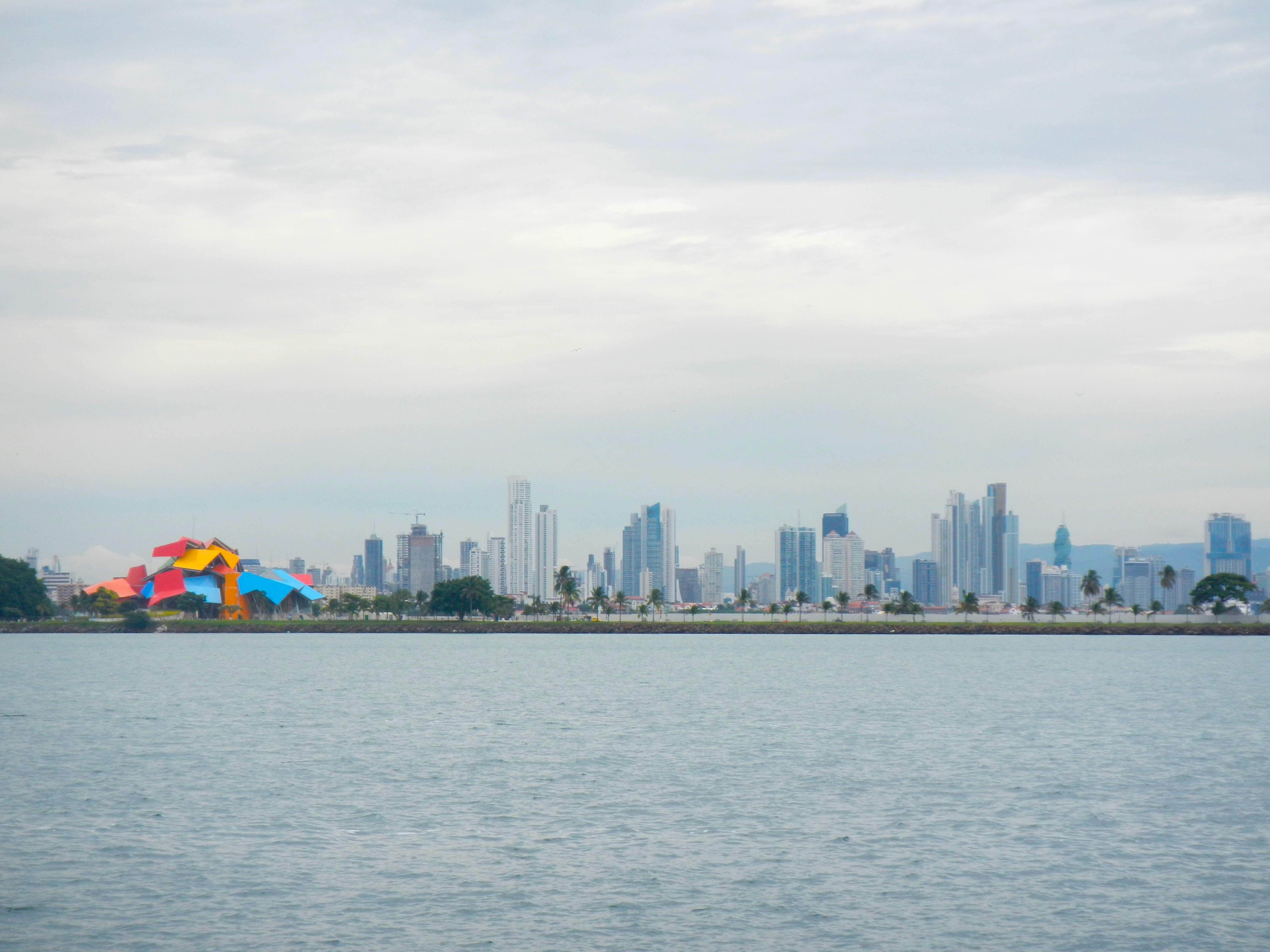
Frank Gehry-designed Biodiversity Museum adds a pop of color to the skyline of Panama City


Open just two months, Panama's new Metro was terrific way to get around town.

Open just two months, Panama’s new Metro was a terrific way to get around town.

Metro, 35¢ a ride, what a bargain.

Metro, 35¢ a ride, what a bargain.


Lights of Panama City

Lights of Panama City

The city wears many hats, part Miami with its nightlife and high rises dotting the shoreline, part Old San Juan with its charming historic districts, part ghost town of abandoned American housing in the old Canal zone

Old "Canal Zone" housing now stands empty.

Old “Canal Zone” housing now stands empty.

and part bustling port city that, of course, centers around their main cash cow, the Canal.  Oh and lest I forget malls.
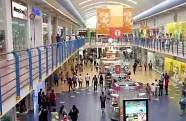
Wall to wall malls

Wall to wall malls

Shopping seems a national sport here.  Panama City hosts 4 ENORMOUS malls both high and low end.

Casa del Whopper

Casa del Whopper

I’m not a shopper, but did enjoy the air conditioning and cheap swimsuits, otherwise they just seemed like a labyrinth of the usual suspects, ubiquitous food courts and multiplex cinemas.  But the main transit center is at one of the malls, so you always had to pass through on your way to everything else.

My friend Robin & I mastered the buses!

My friend Robin & I mastered the buses!

Casco Viejo (Old Quarter)  is the historic district of Panama City.  It was established circa 1673 by the Spanish colonialists.  Majestic homes, cathedrals, government buildings all went neglected around the 1950s – when we all should have invested in the area.  Because now there is a renovation boom.  It is fascinating to see the renaissance in action.   Street by street it changes before your eyes, turn to the left you see a private residence being lovingly restored, to the right are the shells of buildings ripe for repair, look behind you see a rather dodgy area with squatters occupying buildings in ruins and straight ahead are impeccably restored buildings which house restaurants, shops, hotels, embassies, etc.    It has a similar look to the French Quarter in New Orleans without the drunken revelers. (Click on the photos in the gallery to enlarge and read descriptions)

Older you say, you want to see older than 1673.  Alright, Panama Viejo is for you.  This was the original Panama City founded in 1519 before it was shifted to Casco Viejo.  Now they are just ruins which are incorporated into a museum and park.

old and new panama city

old and new panama city

ruins of Panama Viejo

Ruins of Panama Viejo

Panama Viejo juxtaposed to the City today

Panama Viejo juxtaposed to the city today

And of course we ate and drank and watched more soccer during the World Cup than we had in our entire lives.

We hiked off all that food and booze in rain forests and parks throughout the city.

This is a good example of the 18' tides they have on the Pacific side of Panama.

This is a good example of the 18′ tides they have on the Pacific side of Panama.  This will all be underwater at high tide.

Hanging birdsnest in Parque Natural Metropolitano, rainforest inside the city

Hanging birdsnest in Parque Natural Metropolitano, rainforest inside the city

Mango trees are messy

Mango trees are messy

Giant ants love mangos

Giant ants love mangos

View of the city from the top of Parque Natural Metropolitano

View of the city from the top of Parque Natural Metropolitano

And of course we went to the Panama Canal Museum and Miraflores locks to get an education on what was in store for us!!!!

Panama Canal, here we  come!!!!

Panama Canal, here we come!!!!

Sittin’ by the Dock of the Bay…

DSCN3455

Banana Boat

Well, more like the canal.  It is fascinating to be moored here only a football field’s length or so outside the ship channel leading to the canal.  Gigantic ships glide back and forth along it at all hours of the day and night. IMG_0403

Japanese Navy Ship

Japanese Navy Ship

IMG_0418

See how this cargo ship dwarfs Neko (right side of photo)

See how this cargo ship dwarfs Neko (right side of photo, closest boat to cargo ship)

We were pleasantly surprised that they actually throw up very little wake to roll us around.  The work boats on the other hand, are a completely different story.

Go Speed Racer Go

Go Speed Racer Go

Boats come and go allowing us to be neighbors with few interesting boats.

Open 50 raceboat used as a cruiser

Open 50 raceboat used as a cruiser

Falcor-a Gunboat owned by pro snowboarder Travis Rice

Falcor-a Gunboat owned by pro snowboarder Travis Rice

The boats swing according to the current except around slack tide, when the wind dominates.  Since we have a lot of windage and are very light with no deep keel, we turn before the boats around us.  This has brought us into contact with PapaChino, the local fishing boat moored right next to us, on several occasions.

Papa

So we have had to shorten the mooring lines and keep a sharp eye on that thing to keep it off the back of our boat.

BYC dock

BYC dock

The “yacht club’s” dock is a rusting, jagged metal thing that canal work boats and ferries use to pick up passengers and supplies.  We don’t want to tie up to it but we will have to in order to fuel up for our transit and install the repaired dagger board.  The water is horribly dirty, so we are not using our watermaker but ferrying jugs of water back from the dock each time we go in.  The incessant rain and humidity is causing mold to sprout on everything, bleach is Mary’s best friend.

Daily lighting storms

Daily lighting storms

We aren't in California anymore.  Cough, cough, cough

We aren’t in California anymore. Cough, cough, cough

It all makes you think it is miserable here, doesn’t it?  Well, we are actually having a pretty good time.  Panama City is a large, diverse and interesting metropolis.  We like cities like this which do not depend solely on tourism as they give a better feel for what life is really like. We have done some great sightseeing around Panama and always like getting to a big city after weeks out in the wilderness.  So, although we are about ready to move on, our time in Panama City was quite enjoyable. For more info about it, click here see Mary’s post.

Panama Canal Transit 7/5/14

This Saturday, July 5th is our transit date for the Panama Canal.  If you’d like to see us in action, you can watch on the live web cam.
https://www.pancanal.com/eng/photo/camera-java.html?cam=MirafloresHi

Make sure you click the tab that says “High Resolution Miraflores” (the regular camera is out of service), Then click the magnifying glass icon to enlarge.  The image refreshes every minute so you will see us stagger step through.

Schedules can change throughout the day, but we should be at Miraflores Locks (our first lock) between 9-10am (Central Time)   If possible, I will update on Facebook when we are getting close.   And of course we will wave to the camera.

You will have a second chance to see us in the Gatun Locks later in the day, maybe around 2pm (Central Time).  Again I’ll try to give updates via FB.   You can click on the “Gatun Locks” tab as well as the tab for “High Resolution Gatun” for two different angles.

And if anyone wants to grab a screen shot or two of us from the web cam, we’d love a copy and we will include it in our post about our transit.

Neko Rock

You didn’t think I would leave that cliff-hanger of a post out there for too long, did you? So we found the island with the little submarine on it.  Isla San Telmo is a gorgeous uninhabited islet which has been taken over by pelicans, thousands of them.

Pelicans at San Telmo

Pelicans at San Telmo

Pelican nesting sanctuary

Pelican nesting sanctuary

San Telmo is one of 200 islands within the Islas Las Perlas archipelago, about 40 miles from Panama City.  San Telmo beach

Tarzan needs to lay off the carbs

Tarzan needs to lay off the carbs

frangipani flower

frangipani flower

Most of the islands are uninhabited and a few have served as location for the reality show Survivor.  las perlasWe anchored in uneven ground about a 1/4 mile offshore from the little sub. The ancient artifact is about 20 feet long and made of steel that looks like it was 2 inches thick originally.

150 year old pearl diving submarine

150 year old pearl diving submarine

Its amazing to me that its still there more or less intact after nearly a century and a half of being covered and uncovered by the tides as it sits in its final resting spot up on the sandy beach. I like to imagine what it was like when the thing was originally deployed around the time when the French were just starting to dig their proposed sea-level canal (read the fascinating The Path Between the Seas), most ships still used sails to get around and Panama was a remote outpost of Colombia. How futuristic it must have seemed for this underwater contraption to set out on its pearl-hunting mission. The Las Perlas (the pearls) are so named because they were abundant in those natural jewels – so much so that someone built one of the first submarines just to exploit them. What caused the poor crew to ascend too quickly and get decompression sickness? How did it all go wrong? Who knows. All that we have to go on is the rusting steel hulk and our imagination.

Pearl diving sub

Pearl diving sub

The charts of this area are terrible – generally based on surveys conducted decades, or even a century, ago and containing very little detail. Areas like these see little commercial shipping, so little official cartographic attention is devoted to them. In addition to two different sets of charts, we rely on guidebooks written by people who have independently surveyed the area and prepared their own charts for certain locations. All the charts we had for this area, when they had any detail at all, showed us in waters with a minimum depth of about 20 feet at low tide and that is about what we saw. However, when we upped anchor to leave and were slowly motoring out of the anchorage, the boat suddenly lurched to the right and we slowed to a stop with horrible crunching sounds. These are such unnatural motions and sounds for a boat that it causes instantaneous confusion and panic. It took several seconds for me to compute what had happened and get the boat into deeper water. We had hit an uncharted rock pinnacle! We were moving at about 4 knots when the water went instantaneously from 30 feet deep to about 4 feet. It was not shallow water because once we ground horribly over the thing we were back in 30 feet of water. We frantically lifted floorboards and opened hatches to inspect for water intrusion but thankfully the boat was dry. Out in these remote islands there is no assistance for miles around so we were on our own as to what to do about it.

We slowly puttered to our next anchorage to gather our wits and plan next steps. Wouldn’t you know it, but just then the skies opened and deluged us with one of Panama’s patented rainstorms. Being out in one of these you actually feel the weight of so much water coming down. The rain makes visibility so bad that you can’t see even the front of the boat, let alone land or anything else out in the water (including the many logs and trees that float out of the rivers and estuaries and must be dodged). We were left to rely on our instruments, which had just tragically let us down, to get to our anchorage. We slowed to a crawl and with frazzled nerves finally got the anchor down in a safe spot. I dove to inspect the damage. One of our daggerboards (large foil-shaped boards that we raise and lower to act as keels) and skegs (a small keel-like appendage forward of the propeller) were damaged in the  impact. And our rudder, the last thing to hit the rock as we slid by, had its bottom corner chipped open. We have saildrives for propulsion. These are like outboard motor legs that stick straight down through the bottom of the boat just in front of the rudders and have a propeller on the end. Miraculously the rock passed just under the propeller and saildrive leg. Even though they are only barely higher than the rudder, they were unscathed. The rock must have passed only an inch or so below them. If they had hit the rock, it is likely the drive would have shifted on its mounting and let water into the engine compartment. Our boat is broken into water tight segments and since it is built of foam-cored fiberglass with no lead keel, it is very difficult to sink. So this would have flooded the engine room but not sank us. Nevertheless, it was a huge tragedy narrowly averted.  Still and all, we had some damage to ponder and immediately began planning what to do.

location of rock - note the drastic change of our track

location of rock – note the drastic change of our track

We have given the coordinates of the rock to all our friends who will go through this area.  Some are labelling it as “Neko’s Rock” – we hope the name doesn’t stick.  If you are heading this way, mark it on your chart 08 17.129N  078 50.868W

Next:  Boat repairs in remote places.